Trees in the desert project
In 2024, the state capital of Wiesbaden is implementing climate adaptation measures in severely overheated areas of the city. Heavily sealed areas with high temperatures, low ventilation and fresh air supply are to be greened in parts and thus upgraded.
This improves the microclimate and the quality of stay for citizens. Another advantage is that the additional plants create a network with the surrounding green spaces and thus specifically promote biodiversity.
The project is supported by the federal government's "Adaptation of urban spaces to climate change" funding program on the basis of a decision by the German Bundestag.

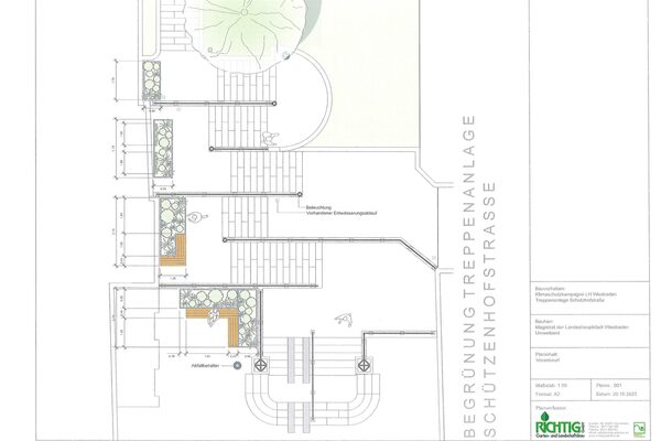
Sub-project greening the Schützenhof staircase
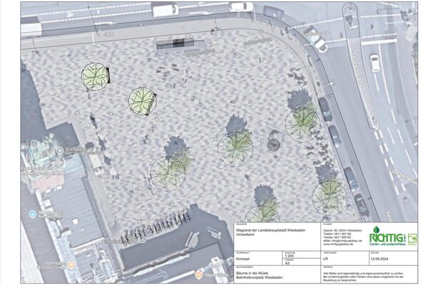
The first sub-projects are the greening of the Schützenhof steps and the planting of trees on the station forecourt. Four planters with shrubs that are well adapted to dry locations and provide a habitat for native insects will be installed on the Schützenhof steps. Benches invite you to linger (for design see "Further information").
On the station forecourt, two large planting islands with seating are each planted with a large-crowned tree. Heat- and drought-tolerant tree and plant species are to be used.
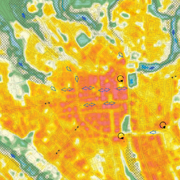
Climate function map shows overheated areas
The climate function map (2017) produced by the Environmental Agency of the City of Wiesbaden identifies the project locations as a highly intensive inner-city overheating area with limited air exchange. The very high degree of sealing (> 90 percent) with low air exchange leads to intense overheating during the day in the summer months and very delayed and only slight cooling at night. Air conduction and ventilation paths that could transport cooler air masses from the rural surroundings into the city center are disrupted by the dense development.
The KLIMPRAX project (Klimawandel in der Praxis, 2017) carried out by the Hessian State Agency for Nature Conservation, Environment and Geology (HLNUG) confirms this assessment. The KLIMPRAX results indicate that the number of hot days and tropical nights is expected to double by 2060. The full results report can be viewed via the link at the bottom of the page. Due to the high population density and the large proportion of very old people in the city center, the population at the selected locations will be significantly affected and exposed.
The climate function map and other maps on the topic of urban climate are publicly available on the city's geoportal (see below). Here, the topics of climate assessment, bioclimatic load, sensitivity and impact on the population can be viewed, as well as the number of hot days, summer days and tropical nights in the past and in the future.
In the city's current climate analysis map (2022), the areas of the station forecourt and Schützenhoftreppe are also shown to be heavily overheated. These are pronounced heat islands with high levels of stress, which are caused by high density with little vegetation and a lack of ventilation.
Sponsors

Further information
Contact us
Environmental Agency
Address
65189 Wiesbaden
Postal address
65029 Wiesbaden
Arrival
Notes on public transport
Bus stop Statistisches Bundesamt; bus lines 16, 22, 27, 28, 37, 45, X26, x72, 262
Telephone
Information on accessibility
- Barrier-free access is available
- The WC is barrier-free